Environmental assessment of aquatic ecosystem of Upper Ganga Basin
Himalayan Ecosystem resources are critical on the face of natural disturbances, anthropogenic activities and climate change. Rivers are the most important natural resource for human development but it has become more polluted by indiscriminate disposal of sewage, industrial waste and overabundance of human activities, which affects its physico-chemical characteristics. Regular water quality monitoring of the water resources is absolutely necessary to assess the quality of water for ecosystem health and hygiene, industrial use, agricultural use and domestic use (Pandey et al., 1999).
Climate change is altering the temporal and spatial distribution of different components of hydrologic cycle. Any change in the quality and quantity of the Himalayan tributaries of River Ganga under the climate change regime will impact the quality parameters of River Ganga. Hence, it becomes imperative to study the impact of climate change on the river ecology
This study was undertaken to understand the basic hydrology and associated water quality, ecology and biodiversity in Upper Ganga Basin for sustainable development of natural resources so that ecosystem stability is maintained. The study area and different zones for biodiversity analysis are given in Figure – 1 and 2.
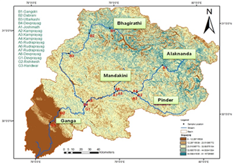
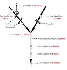
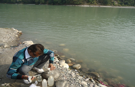
Fifteen sampling sites (4 sites on River Bhagirathi, 8 sites on River Alaknanda and 3 sites on River Ganga) have been selected for water quality assessment in the Upper Ganga Basin. Water samples were collected from the selected sites on monthly basis and bed sediment samples once and analysed for physico-chemical parameters and metal concentrations. Bed sediments of 0-210 m size was digested using acid (H2O2+HNO3 mixture for metal analysis. Chemical mass balance approach has been employed to evaluate the contribution built up by point and non-point sources of pollution. For aquatic biodiversity study, eight sampling zones were identified on Rivers Alaknanda, Bhagirathi, Bhilangana and Ganga. Assessment of aquatic habitat parameters (Depth, Velocity, slope, gradient, substrate, pH, Conductivity, water temperature (WT), DO, BOD, TDS) and aquatic biodiversity (Phytoplankton, Zooplankton, Benthos, and Piscine fauna with their distribution, species richness and abundances) on selected zones of river stretches. Establishing relationships between the abundance of aquatic species and habitat characteristics on monthly basis. Development habitat suitability curves for the aquatic species of Ganga river up to Haridwar and to use these curves for the assessment of environmental flows using habitat simulation modelling.
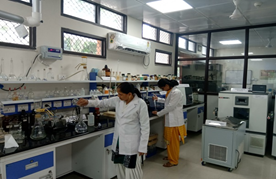
Analysis of various hydro-chemical parameters show that all parameters are within permissible limits of river water quality, except COD and TSS. Anthropogenic pollution is responsible for high concentration of COD. Unexpectedly high TSS at all the locations may be attributed to unstable and young Himalayan geology, from where silt and rocks are easily carried off. Deforestation in the catchment area of the river and rapid urbanization in river flood plains also enhance TSS.
The anion chemistry for all sampling sites and seasons were observed in decreasing order of HCO3->SO42->Cl->NO3-. While the order of concentration of cations varied as Ca2+>Mg2+>Na+>K+. The higher concentration of HCO3- in river water and its positive correlation with Ca and Mg indicates their common source and may be attributed for dissolution of calcite minerals prevalent in the study area. Sulphate is a major ion in these waters and may have been derived from oxidation of pyrites, which occur as pyritous-carbonaceous slates, which is the main proton producing process for chemical weathering in the study area.
The relatively high contribution of (Ca+Mg) to the total cations (TZ+) and high (Ca+Mg)/(Na+K) ratio indicate that carbonate weathering of granites is a major source of dissolved ions in the surface water. Low ratio of Na+ to Cl- indicates low contribution from atmospheric precipitation and evaporates dissolution and negates possible impact of atmospheric pollution on the river water. This is confirmed by Gibbs plot also.
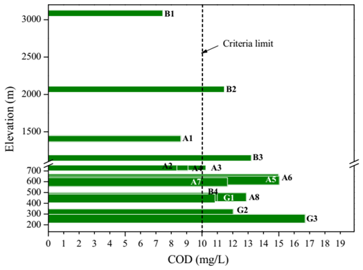
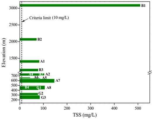
A simple indirect chemical mass balance approach using upstream and downstream chemical and hydrological data has been used for assessing the NPS contribution in the stretch of River Alaknanda of Upper Ganga System successfully and more contribution (>30-50%) for almost all constituents from uncharacterised sources was observed in the months of November to February, which may be attributed to intense agricultural activities during the winter months, particularly cereals and vegetables along with the runoff due to winter rains / snowmelt coming from the landscape.
All analysed dissolved metal concentrations of Fe, Mn, Cu, Cr, Ni, Zn, Pb, and Cd analyzed in water samples of Upper Ganga Basin are well within acceptable limit of river water, except dissolved iron, which may be attributed to various processes, oxidation-reduction reactions that occur in nature, including weathering of iron rich minerals. All water samples of the study area are classified as “near-neutral and low-metal” as proposed by Ficklin diagram.
Enrichment Factor value was calculated for different metals and highest was observed for Mn, followed by Cu, Cr, Ni, Pb, Cd and Zn, which illustrates that all these elements vary from unpolluted to very smaller enrichment. The general trend for relative mobility is observed to be Fe>Mn>Cu>Cd>Pb>Cr>Ni>Zn.
The adsorption of metal ions on sediments plays an important role in controlling metal pollution. The overall contribution of coarser fraction of sediments in controlling metal pollution is more as compared to lower fractions. The Kinetic data suggest that the adsorption of metal ions on bed sediments of river Bhagirathi, Alaknanda and Ganga is an endothermic process, which is spontaneous at low temperature. The uptake of metal ions is controlled by both bulk as well as intra-particle diffusion mechanisms.
The meteorological characteristics of Upper Ganga basin have showed increasing trends and ultimately affected the existing ecological and biological characteristics of riverine ecosystem in upper Ganga basin. The water quality and habitat characteristics of different tributaries and main rivers of upper Ganga basin play a significant role to main the food spectrum (Phytoplankton, zooplankton & benthic organisms) as trophic food chain for rich fish resource present in these river ecosystems. The keystone species for upper (>1500m), middle (500-1500m) and lower (<500m) zones are Brown Trout, Snow Trout and Golden Mahseer respectively.
The habitat suitability curves for keystone species were developed which may be used for the habitat simulation modelling. The output of the habitat simulation modelling is the Area Weighted Suitability (m2/m of reach length) which indicates the suitability of a particular discharge for the habitat sustenance. Based on the variability of AWS for the historical flow variability, AWS duration analysis may be carried out in the SEFA software which may further be used for selecting a particular level of AWS for providing reasonable habitat for different seasons.
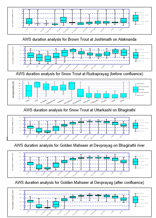
Assuming that the environmental flows may be kept for maintaining the median or higher values of AWS for sustenance of keystone aquatic species, it was found that the recommended e-flows are falling in the range from 26.32 to 41.81 % of average monthly flows at Joshimath site, from 20.94 to 38.64% of average monthly flows at Rudraprayag site, from 21.30 to 27.91% of average monthly flows at Uttarkashi, from 21.47 to 29.71% of average monthly flows at Devprayag site on Bhagirathi river, from 23.67 to 33.81% of average monthly flows at Devprayag site (after confluence) and from 24.66 to 37.17% of average monthly flows at Rishikesh site.