Real-time snow cover information system for Upper Ganga basin
Snow accumulation and ablation are seasonal phenomena in Himalaya. Snow cover depletion curves have been useful input in hydrological models based on empirical degree day approach which has been widely used in runoff estimation and forecasting. Snow cover is derived from remotely sensed data as snow is clearly identifiable in satellite images. However, in certain circumstances such as shadow areas, forest canopy, and cloud cover, proper image processing techniques over multi-temporal, multi-spectral and multi-resolution remotely sensed data need to be adopted for estimation of snow pixels. The daily snow extent maps from MODIS sensors onboard Terra and Aqua satellites are available since year 2000 and 2002 with spatial resolution of 500 m. National Snow and Ice Data Centre provides MODIS SCE Collection 6 with NDSI (Normalized Difference Snow Index) snow cover extent (SCE) maps from year 2000 onwards. NDSI uses Green and Short Wave Infrared (SWIR) bands and is useful index in discriminating snow from bright soil, rocks and clouds. For snow, the index has high value for snow compared to other objects. The main objective of this sub-project was to estimate the spatial and temporal snow cover areas in Himalayan river basins. For this purpose, 8-day global snow extent maps (NSIDC Collection 6 MOD10A1) from MODIS sensors onboard Terra and Aqua satellites at 500 m resolution have been utilized to finalize the snow cover areas. Cloud obscured pixels is a main limitation of MODIS snow cover maps which require the post-processing of the SCE maps. Since daily SCE maps have cloud cover, 8-day SCE maps were used to filter-out the effects of clouds. The maps were further post-processed using altitude mask, and temporal and spatial filters. Maps were quality-checked. Flow chart of the procedure is given in Figure – 1.
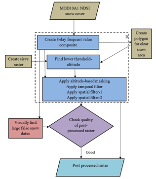
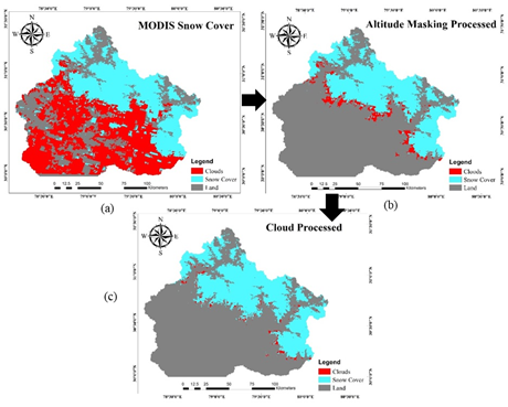
Some steps of post-processing are briefly described here. MODIS Terra and Aqua data are acquired at different time of the day. For non-persistent cloud at sub-daily scale, a pixel may not have cloud cover on both Terra and Aqua data. Thus, by combining MODIS Terra and Aqua SCE maps and reclassifying cloud pixel in the maps based on Terra/ Aqua with non-cloud pixel of maps based on Aqua/ Terra, a reduction in cloud extent is achieved. In temporal filtering, multi-date snow extent maps are combined. This step is based on premise of non-persistence in cloud coverage. In this step, for reduction of cloud-obscured pixels, information of clear pixels of preceding and succeeding dates is used. Most of the approaches used in this step, give higher priority to the clear atmospheric information at closer temporal distance than those far away temporally. The method also requires prevalence of same class, either snow or non-snow on preceding and succeeding days. Spatial filtering is based on the premise that the classes in thematic maps, in general, are spatially contiguous. A majority spatial filter is applied to thematic maps to reduce noise, e.g. cloud cover and the noise pixels, which are of smaller size than the size of the spatial filter are removed. Altitude-based masking is used to reduce cloud and false snow pixels. At the end of snow accumulation and melt seasons, minimum snow elevations are lowest and highest respectively. For any day, the elevations range, where both snow and land pixels occur, is called snow transition elevation. In altitude-based masking, the cloud pixels below the minimum snow transition elevation are reclassified to land pixels while the cloud pixels above the maximum snow transition elevations are reclassified to snow pixels. Cloud pixels, in the snow transition elevations, are reclassified as partial snow pixels. Steps for cloud removal in SCE maps is illustrated in Figure – 2.
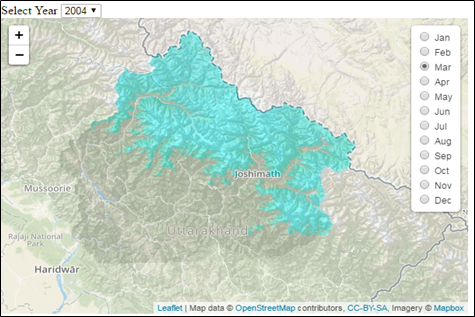
In this study, entire processing work flow, namely deriving daily and 8-day SCE, post processing of SCE and deriving zonal, seasonal statistics and trends and plotting of time series is implemented in R- software and 8-day snow cover areas have been finalized for the 11 river basins in the Indian part of the pan-Himalayas (namely Beas, Jhelum, Ravi and Satluj in Indus basin, Sarda, Upper Ganga and Yamuna in Ganga basin and Dibang, Subansiri and Teesta in Eastern Himalayas) from the year 2000 to 2020. Using R-scripts, extensive analysis has been carried out in terms of monthly, seasonal and annual average snow cover areas and their trends in different elevation bands. In this study, all SCE estimations have been provided in tabular and graphical form. Web-GIS application has been developed using hypertext markup language for the easy visualization of snow cover extent in any month in any year. Web-GIS map for a basin is presented in Figure – 3. Such maps can be displayed through project website for all 11 basins for all months during years from 2000 to 2020.
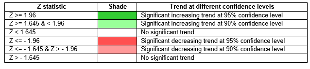
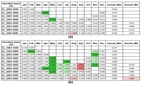
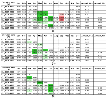
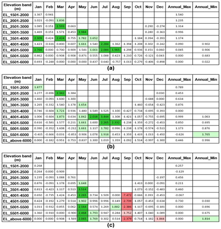
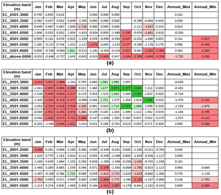
After finalization of monthly snow cover area maps in all 11 selected basins of Indian Himalayas, extensive trend analysis has been carried out during the period from 2000 to 2020. Here, the trend results of SCA for various months and seasons are presented from Figure – 4 to 7 for different Himalayan basins in India. The colour scheme adopted for rising/falling trends at different significance levels are shown below: