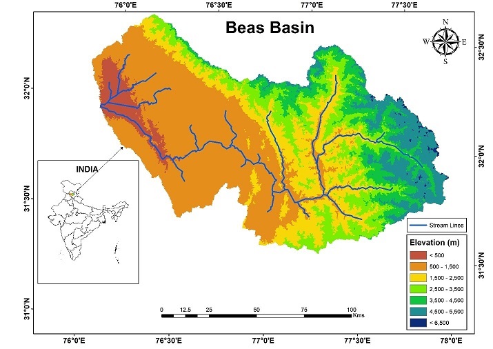
Study Area Map of Beas Basin
The Beas River is an important river of the Indus River system. Beas River originates from the eastern slopes of Rohtang pass of Himalayas at an elevation of 3900 m and flows in nearly north- south direction up to Larji. The Beas basin up to Pong dam has been taken for the present study. The catchment of the Beas basin up to Pong dam is 12606 sq. km. Mostly the catchment area comprises of precipitous slopes and the rocks are mainly bare. It joins Satluj River near Harika, after being joined by a few tributaries A major portion of the catchment lies under degraded forests and cultivated land and therefore the proportion of the silt and sand are of fine, medium and coarse configuration. Steep slopes are very common but are terraced at several places in the lower ranges up to an elevation of 1982 m for agricultural purposes. In certain reaches, thick forests exist mostly between elevations of 1830 m to 2744 m.
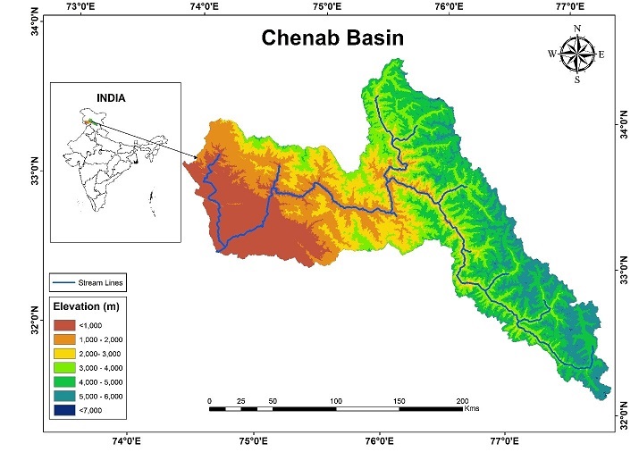
Study Area Map of Chenab Basin
The river Chenab is formed after the two streams; the Chandra and the Bhaga merge with each other at Tandi. The Chandra and the Bhaga originate from the South-West and North West faces of Barelacha pass respectively in the Himalayan canton of Lahuland Spiti valley in Himachal Pradesh. The Chandra initially flowing Southeast for about 88 kms sweeps round the base of the mid Himalayas and joins the Bhaga at Tandi, after traversing a total length of about 125 km. There-after the united stream, known as Chandra Bhaga (Chenab), flows in a North-Westerly course for about 48 km where it receives its first major tributary the Miyar Nallah on the right bank. Then it flows another 96 km generally in a Northerly direction in Himachal Pradesh till it crosses the Pangi valley before entering to Paddar area of Kishtwar district of Jammu and Kashmir State. In Padder valley it is joined by Bhut nallah at Gulabgarh. The river flows in a North West direction in this reach for a distance of 61 km where it is joined on the right bank by its biggest tributary, the Marusudar at Bhandarkot. Further downstream, the river flows in a Southerly direction for a distance of about 32 km up to Thathri and then takes a Westerly course. In this reach, about 15 km downstream of Thathari, Niru Nallah joins the Chenab River on its left Bank. Thereafter the river flows generally in a North West direction for another 41 km till it receives a tributary Bischeleri on the right bank. After wards the river traverses in west direction for a distance of about 64 km. In this reach a number of small streams namely Cheneni, Talsuen, Yabu, Ans join on the right bank, and Katu Nallah, Mandial and Painthal Khad joins on the left bank. At the downstream of Ans river confluence, the river changes its direction and takes a Southerly course for about 55 km up to Akhnoor. Thereafter it enters into Sialkot district of Pakistan. The catchment of the Chenab basin is 28502 sq. km that has been taken for the present study.
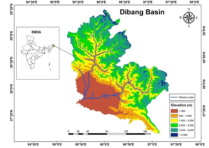
Study Area Map of Dibang Basin
Dibang River is a tributary river of the Brahmaputra that originates and flows through the Mishmi Hills and northeast India from the state of Arunachal Pradesh. The drainage basin of the river within Arunachal Pradesh covers the districts of Dibang Valley and Lower Dibang Valley. The Mishmi Hills lie in the upper course of the Dibang which enters the plains at Bomjir, Dambuk etc. Between Bomjir (Nizamghat) and Sadiya the Dibang has a steep river gradient and exhibits braided channel morphology, with its width varying from 4 to 9 km. The Dibang, with a total length of 195 km, enters the River Lohit north of the Dibru-Saikhowa sanctuary near the Assamese town of Sadiya. The Sisar, Mathun, Tangon, Dri, Ithun and Emra are the major tributaries of the Dibang. The Dibang is also joined by a number of tributaries such as the Airi, Ilu, Imu, Ahi, Ashu, Epipani and Eze (Deopani) rivers during its course. Most of these rivers join it in the upper course in the hills thus giving it a wide fan shaped catchment region.
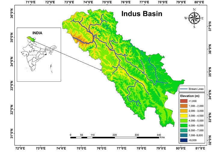
Study Area Map of Indus Basin
The Indus is one of the most important drainage systems of the subcontinent of India. It has a length of 2880 km, of which 709 km lies in India. The catchment area of the Indus is about 1165000 sq. km, out of which about 130649 sq. km has been taken for the present study. The Indus is the western most River system in the subcontinent. Jhelum, Chenab, Ravi, Beas and Satluj are its main tributaries. The Indus originates from the Bokhar Chu (glacier) in northern slopes of Mt. Kailash (6714m). It drains the largest number of glaciers and mountain slopes of the Karakorum, Ladakh, Zaskarand Himalayan Ranges. Originating from the Kailash Mountain, it flows in a constricted valley north-westward through Tibet, where it is called as Singi Khamban or Lion's mouth. In ladakh it follows a long nearly straight course between the Ladakh range and the Zaskar range. Moving north-westward, the Indus is joined by the Shyok-Nubra tributaries. These tributaries arise from the Siachin Glacier (Karakoram Range). At Skardu, at a little distance below the Shyok, the Shigar River meets River Indus. Gilgit is another important tributary which comes from the west to join Indus. Downward; the Indus crosses the central Himalayan range through a huge synclinal gorge. The River passes by the Nanga-Parvat and turns south-west to enter Pakistan.
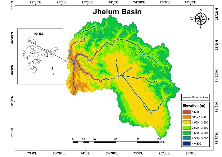
Study Area Map of Jhelum Basin
The Jhelum River Basin is located in the Union territory of Jammu and Kashmir towards northern India. The total catchment of Jhelum basin is about 34775 sq. km, with a total length of 402 km out of which 26089 sq. km has taken for the present study. The basin possesses a main drainage channel in the form of Jhelum River, besides having a fairly well-established drainage system. It is encompassed by Pir Panjal mountains in the southwest and Greater Himalaya mountain range in the northeast. Previous studies have regarded a spring at Verinag, Anantnag towards southeastern part of the Kashmir as the origin of the River. However, the present research affirms Lidder stream to be the origin of the Jhelum River, being the longest drainage channel wherefrom water source-point commences. The River then meanders through central city (Srinagar) of Valley before it enters into Wular lake in the northwestern direction. After exiting from the lake, the river cuts across Pir Panjal through Baramulla-Uri gorge and then flows into Muzaffarabad. The climate of the region is of sub-humid temperate type with unpredictable weather conditions owing to its rugged topography.
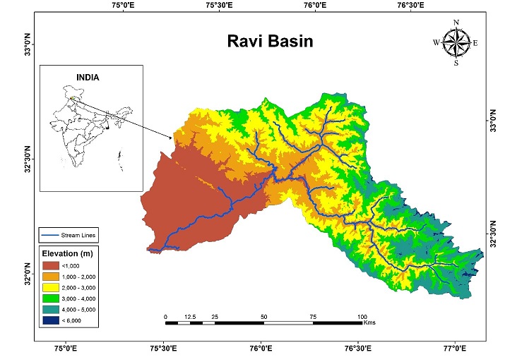
Study Area Map of Ravi Basin
The Ravi River originates in the Himalayas in the Chamba district of Himachal Pradesh. The River drains a total catchment area of 14,442 sq. km out of which 8427 sq. km has taken for the present study. Flowing westward, it is hemmed by the Pir Panjal and Dhauladhar ranges, forming a triangular zone. It follows a north-westerly course and is a perennial River. It is the smallest of the five Punjab Rivers that rises from glacier fields at an elevation of 4,300 m, on the southern side of the Mid Himalayas. It flows through Barabhangal, Bara Bansu and Chamba districts. It flows in rapids in its initial reaches with boulders seen scattered in the bed of the River. The Ravi River in this reach flows in a gorge with a River bed slope of 1:185 ft. per mile, and is mostly fed by snow melt, as this region falls under rain shadow zone. Two of its major tributaries, the Budhil and Nai or Dhona join 40 miles (64 km) downstream from its source. It is the most important River of the district Kathua. The length of the River in the district is approximately 55 km.
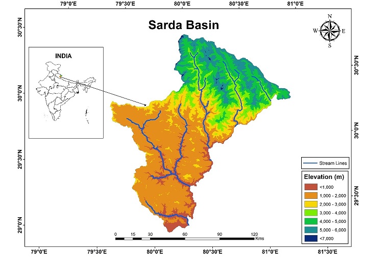
Study Area Map of Sarda Basin
The Sarda River, also called Kali River and Mahakali River, originates at Kalapani in the Himalayas at an elevation of 3,600 m in the Pithoragarh district in Uttarakhand, India. It flows along Nepal's western border with India and has a basin area of 14,871 sq. km. It joins Ghaghra River, a tributary of the Ganges. It takes the name Kali River from the union of the two streams at Gunji as it flows through the hills. After Brahmadev Mandi near Tanakpur, it enters the Terai plains, where it is called Sharda River. Almost 1/3rd catchment area of Ganga basin lies in Uttarakhand and Uttar Pradesh. The catchment area of Mahakali is around 15,260 sq. km, large part of which (9,943 sq. km) lies in Uttarakhand and rest lies in Nepal. Mahakali is a transboundary/international river. In whole of South Asia, rivers have played a symbiotic role in the dependence of communities on them, their socio-cultural-economic relations, and mutual economic cooperation and with changing times these inter-linkages needs to be strengthen further. Numerous rivers and streams join the Mahakali from the higher, middle, lower and outer Himalayas and almost each of such confluence (at least of major rivers) acts as a place of socio-cultural, trade festival importance. Before the river encounters Tanakpur barrage (Sarda Ghat) and later Banbasa Barrage, the main river is a free riverine stream. The catchment boundaries of Mahakali/Sarda basin cut across administrative boundaries of 'Far Western' Himalayan region of Nepal comprising four districts of Baitadi, Dadheldhura, Kanchanpur and Darchula through major parts of Pitthoragarh (except the top most NW border), almost whole of Champawat, Bageshwar district (excluding upper part of Kapkot Tehsil) and very small parts of lower Almora and Udham Singh Nagar. In the upper reaches Mahakali/Sarda flows through narrow gorges passing through Garbyang, Tawaghat and Dharchula and spreads as it flows downwards in the lower hills. The upper Sarda Barrage (also known as the Banbasa Barrage) is built here and water of the river is diverted into the Sarda Canal system.
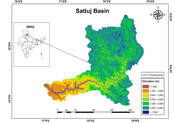
Study Area Map of Satluj Basin
The Satluj River rises as Langchen Khabab in the lakes of Mansarover and Rakastal in the Tibetan Plateau from the southern slopes of Mount Kailash at an elevation of about 4,570 m above mean sea level (msl) and forms one of the main tributaries of Indus River. The total geographical area of Satluj River up to Bhakra dam is about 56,980 sq. km, of which about 37,153 sq. km lies in Tibet. The remaining about 19,827 sq. km area lies in the Indian territory. Indian part of the Satluj basin is elongated in shape. The shape and location of this basin is such that a major part of the basin area lies in the greater Himalayas where heavy snowfall is experienced during winters. The catchment area lies between longitudes 76∘22'E to 78∘42'E and latitudes 31∘ 13'N to 32∘23'N. A major portion of the Satluj basin lies in the greater Himalayan range. The elevation of the catchment varies widely from about 500 m to 7,000 m above msl, although only a very small area exists above 6,000 m. The mean elevation of the basin is about 3,600 m. The gradient is very steep near its source and gradually reduces downstream. Owing to large differences in seasonal temperatures and great range of elevation in the catchment, the snowline is highly variable, descending to an elevation of about 2,000 m during winter.
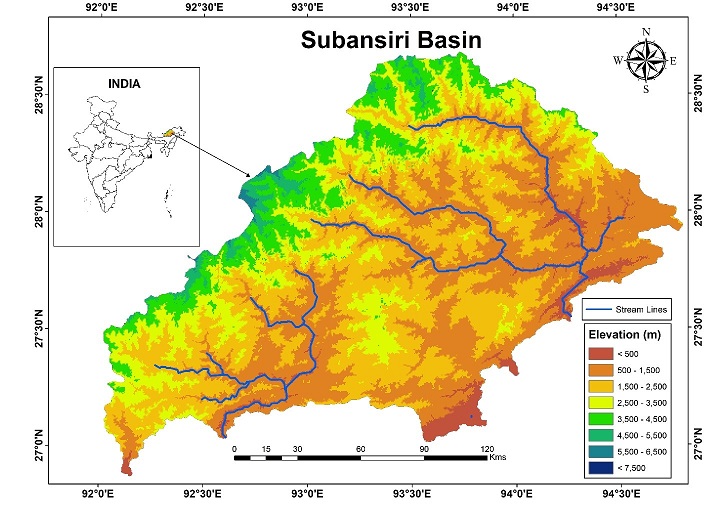
Study Area Map of Subansiri Basin
The Subansiri River is a tributary of the Brahmaputra River in the Indian states of Assam and Arunachal Pradesh, and the Tibet Autonomous Region of China. The Subansiri is 442 km long, with a drainage basin 32,640 Sq. km large. The Subansiri is the largest tributary of the Brahmaputra. Its maximum observed discharge was 18,799 m3/s, and its minimum 131 m3/s. It contributes 7.92% of the Brahmaputra's total flow. The Subansiri River originates in the Himalayas, in China. It flows east and southeast into India, then south to the Assam Valley, where it joins the Brahmaputra River in Lakhimpur district.
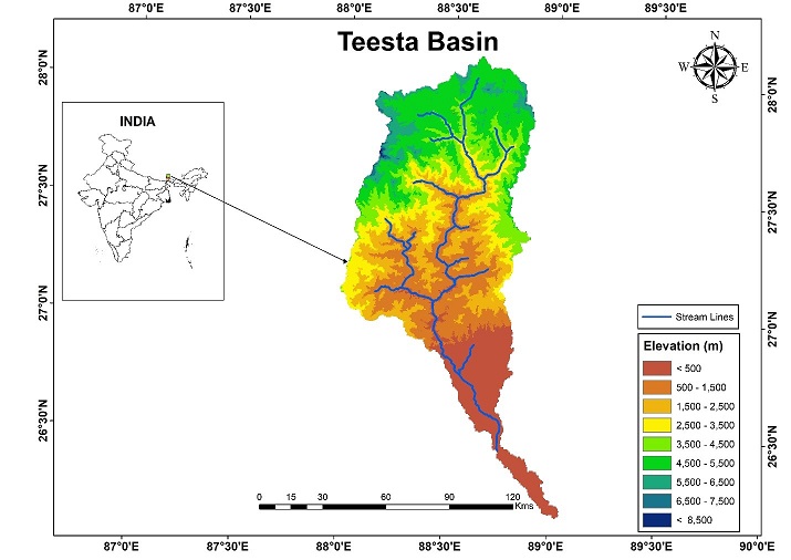
Study Area Map of Teesta Basin
Teesta River, is a 315 km long river that rises in the eastern Himalayas, flows through the Indian states of Sikkim and West Bengal through Bangladesh and enters the Bay of Bengal. It drains an area of 12,370 sq. km. In India, it flows through Darjeeling district and the cities of Rangpo, Jalpaiguri and Mekhliganj. It joins the Jamuna River at Fulchhari in Bangladesh. The Teesta River originates from the Pahunri (or Teesta Kangse) glacier above 7,068 m, and flows southward through gorges and rapids in the Sikkim Himalaya. It is fed by rivulets arising in the Thangu, Yumthang and Donkha mountain ranges. The river then flows past the town of Rangpo where the Rangpo River joins, and where it forms the border between Sikkim and West Bengal up to Teesta Bazaar. Just before the Teesta Bridge, where the roads from Kalimpong and Darjeeling join, the river is met by its main tributary, the Rangeet River. In the Teesta basin, the southwest monsoon normally sets in the third week of May and withdraws in the second week of October. The major portion of the catchment being hilly and the river flowing in steep gradient, heavy rains in the upper and middle catchments has an immediate effect of rendering the plains to flash floods.
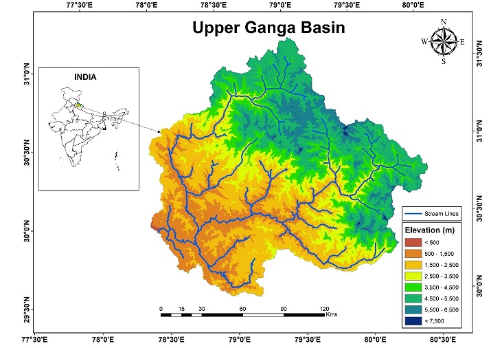
Study Area Map of Upper Ganga Basin
Ganga basin drains nearly 1086000 sq. km in China, Nepal, India and Bangladesh. The Ganga basin up to Rishikesh has been taken for the present study. The catchment of the Ganga basin up to Rishikesh is 20812 sq. km. To the north, Himalaya or lower parallel ranges beyond Himalayas, form the divide of the basin. On the west the river borders the Indus basin and the Aravalli ridge and on the east, river merges with the Brahmaputra. Catchment area of the river lies in the states of Uttarakhand, Uttar Pradesh, Madhya Pradesh, Bihar, Rajasthan, West Bengal, Haryana, Himachal Pradesh, Delhi and Jharkhand in India and whole of Bangladesh, Nepal and Bhutan. The basin has a population of more than 500 million and is the most populated basin in the world. The basin comprises semi-arid valleys in the rain shadow north of the Himalaya, densely forested mountains south of the highest ranges, the scrubby Shiwalik foothills and fertile Gangetic plains. Annual gross and utilizable surface water potential of the basin in India is 525 km3 and 250 km3 respectively. Arable land in the basin is 580,000 sq. km or nearly 29.5% of the cultivable area in India. Northern tributaries such as Kosi, Gandak and Mahananda are the most flood-prone rivers in the basin. Low flow in the basin is causes by scarcity of rainfall outside summer monsoon and sometimes by failure of the monsoon to develop to its normal extent. Kosi, Ghaghara and Gandak are its main northern tributaries.
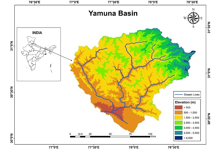
Study Area Map of Yamuna Basin
The Yamuna river is the biggest tributary of the Ganga river. It is also considered as sacred river in India. The Yamuna river originatesin the Tehri Garhwal district of Uttarakhand from the Yamunotri glacier near Banderpoonch peaks (38∘59'N 78∘27'E) at the elevation of about 6,320m above the sea level in the Mussoorie range of lower Himalayas. Arising from the source, the Yamuna river flows through a series of valleys for about 200km in lower Himalayas and then emerges into Indo-Gangetic plains. In the upper reaches, the gradient of the river is steep and the entire geomorphology of the valley has been carved by the erosive action of the river water. In the headwater reach of 200km, the Yamuna draws water from several major streams. The Yamuna river enters Delhi near Palla village after traversing for about 224 km. Further downstream, Yamuna flows through the Agra city which is famous for Taj Mahal. Shortly afterwards, it passes through another historical city, Mathura. The total length of Yamuna from its origin to Allahabad (confluence with Ganga) is 1,376 km and the drainage area is 3,66,223 sq. km. The Yamuna is a mighty river in itself and has a number of tributaries. In its first 170 km stretch, the tributaries the Risiganga, Hanumanganga, Tons and Giri join the main river. Later big rivers, such as the Chambal, the Sind, the Betwa and the Ken join it. The catchment of the Yamuna river system covers the parts of Uttar Pradesh, Uttarakhand, Himachal Pradesh, Haryana, Rajasthan, Madhya Pradesh and Delhi.
Methodology and Results
Elevation Band - Wise Temporal Variation of Snow Cover Area
Web - GIS Based Snow Cover Area Maps
Field Visit